
Ingleborough
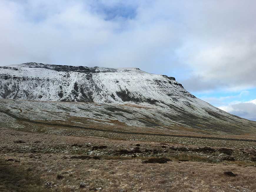
Ingleborough is one of the most distinctive mountains in England, instantly recognisable by its flat-topped summit plateau rising to 723 metres (2,372 feet). It forms one third of the famous Yorkshire Three Peaks challenge and is steeped in history, geology and folklore.
On our organised walks, Ingleborough is our first peak, walking in an anti-clockwise direction from Chapel-le-Dale.
Height
723m (2,372ft)
Grid Reference
SD 741 745
Ascent Time
1.5 - 2 hours
Distance to Summit
4km (2.5 miles)
History and Heritage
Ingleborough has been a place of human activity for thousands of years. The summit plateau once held an Iron Age hill fort, believed to have been occupied by the Brigantes tribe around 2,000 years ago. The remains of a defensive wall and circular hut foundations can still be traced on the summit.
In 1830, Hornby Castle's owner built a tower on the summit, intending it as a hospitality venue. The tower was destroyed by locals within days of completion, reportedly because they objected to the commercialisation of their mountain. The stone rubble from this tower now forms part of the summit shelter cairn.
During the Victorian era, Ingleborough became a popular destination for early tourists, and the famous Ingleborough Cave was opened to visitors in 1837, making it one of England's oldest show caves.
Geology
Ingleborough's distinctive stepped profile tells a geological story spanning 350 million years. The mountain is built from three main rock types:
- Carboniferous Limestone - The lower slopes and the spectacular limestone pavements around the base are formed from this pale grey rock, riddled with caves and potholes
- Yoredale Series - The middle section alternates between limestone, shale and sandstone, creating the characteristic stepped appearance
- Millstone Grit - The dark, weather-resistant cap rock that forms the distinctive flat summit plateau
The area around Ingleborough contains some of Britain's finest examples of karst landscape, including Gaping Gill (one of the largest underground chambers in Britain), White Scar Cave, and extensive limestone pavement formations.
Routes to the Summit
From Chapel-le-Dale (Yorkshire Three Peaks route)
The standard Yorkshire Three Peaks route approaches Ingleborough from Chapel-le-Dale, following the path past the Old Hill Inn. This is a steady climb with excellent views across to Whernside and the Ribblehead Viaduct. The path is well-marked but can be boggy in sections after rain.
From Ingleton
A popular route starts from Ingleton, passing through Crina Bottom and ascending via the impressive stepped western face. This approach offers dramatic views of the limestone scenery and is often considered the most scenic route to the summit.
From Horton-in-Ribblesdale
The traditional clockwise Three Peaks route approaches from Horton, following the Pennine Way initially before branching off towards Simon Fell and the summit. This is a longer approach but provides a sense of the mountain's scale.
From Clapham
Starting from Clapham village, this route passes the famous Ingleborough Cave and Gaping Gill before ascending the southeastern ridge. It combines geological interest with mountain walking.
Route Description (Yorkshire Three Peaks)
From Whernside and The Old Hill Inn, briefly follow the road to Ribblehead before crossing the stile to the right, and following the marked path. The ascent steepens as you approach the summit plateau, with some rocky sections requiring care. The peak of Ingleborough is marked by a large summit cairn and trig point.
To head back to Horton-in-Ribblesdale, retrace your steps for 200 metres or so before heading off the ridge to your right, over several stiles and on to a lane, where your path heads to the left, and over several more stiles before ending back in Horton-in-Ribblesdale.
What to Expect on the Summit
The summit plateau is surprisingly large, covering approximately 6 hectares. Features include:
- A triangulation pillar (trig point) marking the highest point
- A large wind shelter cairn constructed partly from the 1830 tower ruins
- Remains of the Iron Age hillfort walls
- Panoramic views extending to Morecambe Bay, the Lake District, the Pennines, and on clear days, Blackpool Tower
The summit can be exposed and cold, even in summer. Temperatures are typically 5-8°C cooler than the valley, and wind chill can make it feel much colder. Always carry warm layers and waterproofs.
Parking
Several parking options serve Ingleborough:
- Chapel-le-Dale - Limited roadside parking near the Old Hill Inn (pay at pub if using their facilities)
- Ingleton - Main car park in the village centre (pay and display)
- Clapham - National Park car park (pay and display)
- Horton-in-Ribblesdale - Car park by the Pen-y-Ghent Cafe (pay and display)
Facilities
- The Old Hill Inn (Chapel-le-Dale) - Traditional pub with food, drinks and accommodation
- The Station Inn (Ribblehead) - Pub with food and views of the viaduct
- Ingleton - Full range of shops, cafes, pubs and public toilets
- Clapham - Village shop, cafe, pub and public toilets
Wildlife and Nature
The varied habitats around Ingleborough support diverse wildlife. Look out for:
- Birds - Curlews, lapwings, ring ouzels, and ravens are common. Peregrine falcons nest on the crags
- Limestone flora - The pavements support rare plants including bloody cranesbill, bird's-eye primrose, and mountain pansy
- Upland species - Mountain hares can occasionally be spotted on the higher slopes
Safety Considerations
- The summit plateau can be disorienting in mist - carry a map and compass
- Some rocky scrambling is required on the final approach from certain directions
- Limestone pavements can be slippery when wet - take care around Gaping Gill and cave entrances
- Mobile phone signal is limited on much of the mountain
- Weather can change rapidly - check the forecast and be prepared
Paths on Ingleborough and around Horton-in-Ribblesdale are marked on the OS Explorer OL2 Yorkshire Dales map (at the Three Peaks Shop).
Ready to Climb Ingleborough?
Join one of our fully-supported guided Yorkshire Three Peaks events with experienced mountain leaders.
View Yorkshire Three Peaks DatesIngleborough Route Map
For Yorkshire maps, patches, badges and medals, please see The Three Peaks Shop.
