
Pen-y-Ghent
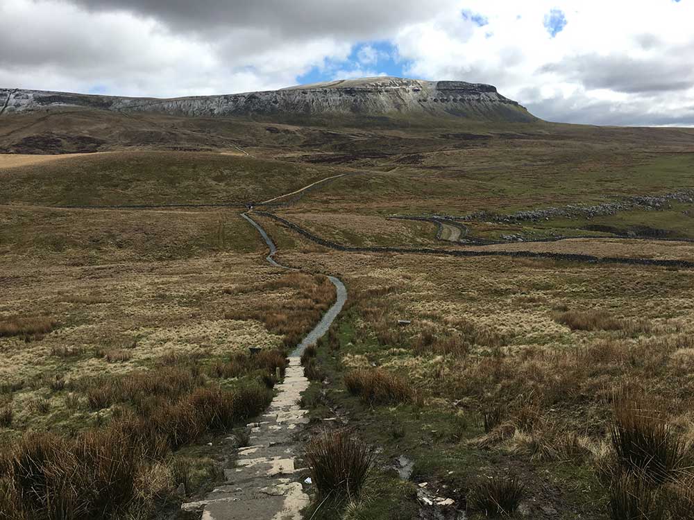
Pen-y-Ghent is perhaps the most recognisable of the Yorkshire Three Peaks, with its distinctive lion-shaped profile dominating the view from Horton-in-Ribblesdale. Rising to 694 metres (2,277 feet), it may be the smallest of the three but offers the most dramatic scrambling sections.
Starting the Yorkshire Three Peaks from Horton-in-Ribblesdale, and walking in the traditional clockwise direction, Pen-y-Ghent is the first peak to be ascended. On our organised events, we start at Chapel-le-Dale and walk Ingleborough first, meaning Pen-y-Ghent is our final summit.
Height
694m (2,277ft)
Grid Reference
SD 838 733
Ascent Time
1 - 1.5 hours
Distance to Summit
3km (2 miles)
The Name
Pen-y-Ghent is one of the few Welsh-named peaks in the Yorkshire Dales, a reminder of the region's Celtic heritage. The name is typically translated as "Hill of the Winds" or "Hill of the Border", though some scholars suggest it may derive from "Hill of the Open Country". The hyphenated spelling reflects traditional usage, though "Penyghent" is also common on maps and signs.
Geology
Pen-y-Ghent's distinctive stepped profile results from its layered geology, similar to the other Yorkshire Three Peaks:
- Carboniferous Limestone - Forms the lower slopes and the characteristic white scars visible from the village
- Yoredale Series - Alternating bands of limestone, shale and sandstone create the stepped appearance on the mountain's flanks
- Millstone Grit - The dark, resistant cap rock that forms the summit plateau and the dramatic nose-shaped cliff on the southern face
The mountain's caves and potholes, including Hunt Pot and Hull Pot (one of England's largest natural holes at 90 metres long and 18 metres deep), are testimony to the limestone's solubility over millions of years.
History and Heritage
Pen-y-Ghent has been an important landmark for centuries. The Pennine Way, Britain's first long-distance footpath (opened in 1965), passes over its summit. The mountain has also been central to the Yorkshire Three Peaks challenge since the walk was first established in the 1880s.
The area around Pen-y-Ghent was once important for lead mining, and evidence of this industry can still be seen in the form of old shafts and spoil heaps on the lower slopes.
Routes to the Summit
From Horton-in-Ribblesdale (Standard Route)
The most popular route begins from the car park in Horton, following the lane to Brackenbottom and then climbing directly up the southern face. This route includes a short but exciting scramble over rocky steps near the summit. Grade: Moderate, with one section of easy scrambling.
Via the Pennine Way (from the North)
The Pennine Way approaches from the north, offering a gentler gradient but a longer walk. This route passes through atmospheric moorland and provides excellent views of the mountain's profile before the final ascent.
Yorkshire Three Peaks Route
When walking the full Three Peaks circuit clockwise from Horton, you ascend Pen-y-Ghent first via the southern scramble, then descend northwards along the Pennine Way before turning west towards Ribblehead and Whernside.
The Scramble
The final approach to Pen-y-Ghent's summit from the south includes a short but memorable scrambling section. Key points:
- The scramble is around 10-15 metres of rocky steps
- Hand-holds are plentiful and the rock is generally sound
- In wet or icy conditions, take extra care as the rocks become slippery
- The scramble is avoidable via a path to the left, though this misses much of the mountain's character
- Most walkers with reasonable mobility manage the scramble without difficulty
This section gives Pen-y-Ghent its reputation as the most "mountaineering-like" of the Yorkshire Three Peaks, despite being the lowest of the three.
What to Expect on the Summit
The summit of Pen-y-Ghent features:
- A triangulation pillar (trig point) on a small rocky outcrop
- A stone wall crossing the summit plateau
- Panoramic views of the Yorkshire Dales, including Ingleborough and Whernside, Fountains Fell, and on clear days, the Lake District and Morecambe Bay
- The distinctive "nose" of the south face visible when looking back from the northern descent
The summit is exposed and can be windy. Temperatures are typically 4-6°C cooler than Horton, and wind chill can be significant.
Parking
The main parking options for Pen-y-Ghent:
- Horton-in-Ribblesdale - Main car park by the Pen-y-Ghent Cafe (pay and display, around £5 for the day). This is the primary starting point for most walkers.
- Roadside Parking - Limited spaces along the road towards Brackenbottom (free but fills early on busy days)
- Dale Head - Small car park on the road north of Horton for those starting from the Pennine Way direction
Facilities in Horton-in-Ribblesdale
- Pen-y-Ghent Cafe - Famous walkers' cafe serving hot food and drinks. Home of the Three Peaks clocking-in system for those timing their challenge.
- The Crown Hotel - Traditional pub with accommodation and meals
- The Golden Lion - Pub with food and outdoor seating
- Public Toilets - Located near the car park
- Holme Farm Campsite - Camping and bunkhouse accommodation
Wildlife and Nature
The varied terrain around Pen-y-Ghent supports distinctive wildlife:
- Birds - Golden plovers, curlews, and red grouse are common on the moorland. Peregrines hunt along the crags.
- Limestone Flora - The scars support specialist plants including mountain avens, bird's-eye primrose, and various orchids
- Peat Bog Species - Sundews and cotton grass thrive in the wet areas of the summit plateau
Safety Considerations
- The scrambling section requires care, especially in wet or icy conditions
- The summit plateau can be boggy - waterproof boots are essential
- Navigation in poor visibility requires map and compass skills
- Hull Pot and Hunt Pot are unfenced - keep clear in poor visibility
- Mobile phone signal is limited around the summit
- Weather can change rapidly - always carry waterproofs and warm layers
Paths on Pen-y-Ghent are marked on the OS Explorer OL2 Yorkshire Dales map (at the Three Peaks Shop).
Ready to Climb Pen-y-Ghent?
Join one of our fully-supported guided Yorkshire Three Peaks events with experienced mountain leaders.
View Yorkshire Three Peaks DatesPen-y-Ghent Route Map
For Yorkshire maps, patches, badges and medals, please see The Three Peaks Shop.
